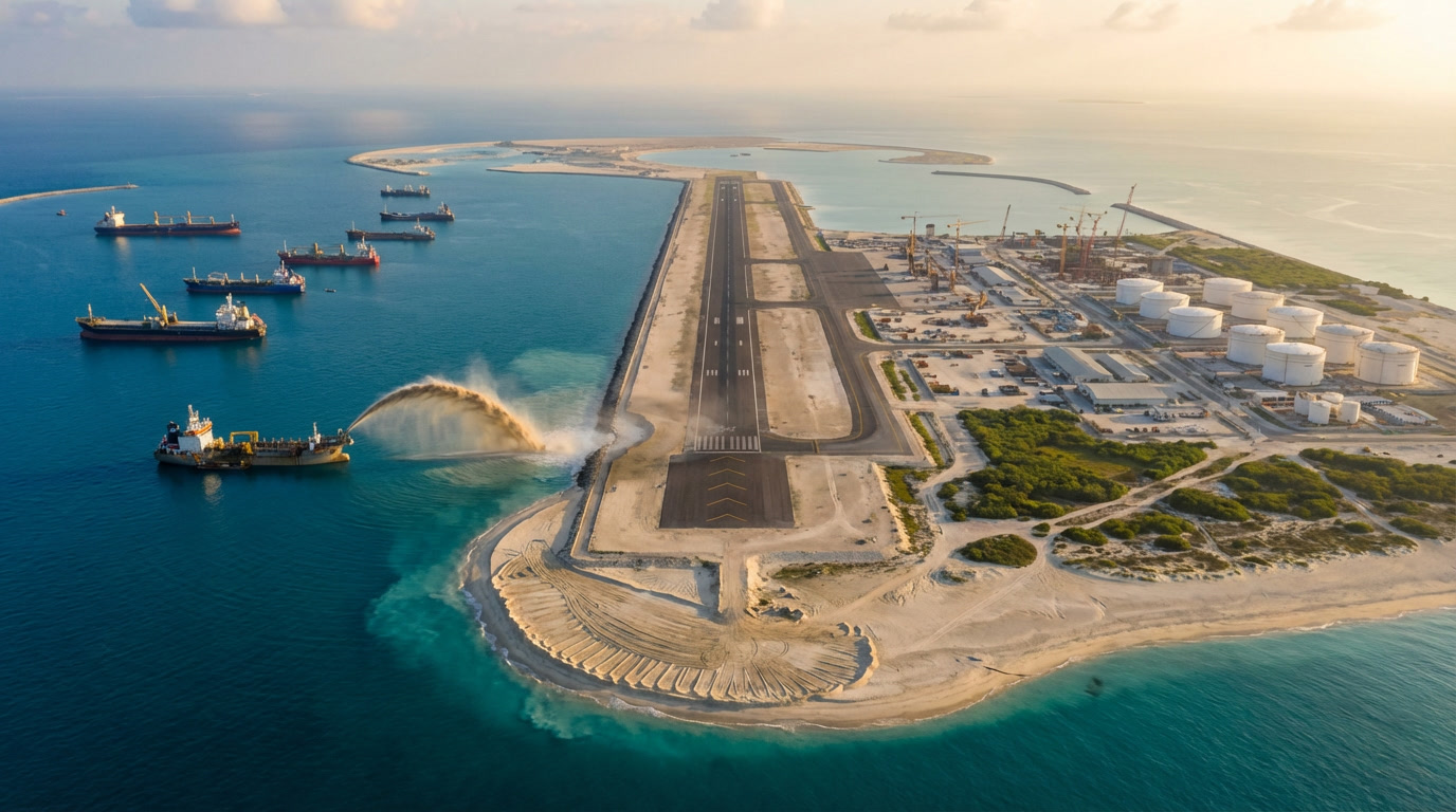
At first, it looks unreal — a pale smear against the deep blue of the South China Sea. Then the outline sharpens: a runway slicing straight across the horizon, radar domes gleaming under the sun, cranes frozen mid-lift. A decade ago, there was nothing here but waves and coral. Now there’s concrete, steel, diesel fumes, and seabirds circling structures that didn’t exist when many of the sailors watching them were still in school.
“This was open water,” one naval officer said quietly during a patrol near the Spratly Islands. “Just sea.” Today, that sea hosts floodlights, fuel tanks, helipads, and rows of buildings anchored to sand that once lay undisturbed on the ocean floor.

For more than 12 years, China has been turning submerged reefs into solid ground. And with every new island, the balance of power in one of the world’s most important waterways shifts a little more.
How China turned reefs into land
On satellite imagery, the transformation feels almost cinematic. A faint coral ring visible at low tide. Months later, dredgers arrive. Then a bright geometric outline appears, followed by straight roads and rectangular pads — shapes nature doesn’t draw.

The process is called land reclamation. The politics behind it are far less neutral.
China focused on reefs and low-tide elevations across the Spratly Islands, a region claimed in parts by the Philippines, Vietnam, Malaysia, Brunei, and Taiwan. Using massive cutter-suction dredgers, crews vacuumed sand from the seabed and pumped it onto fragile reef systems. Bulldozers flattened the slurry. Rock walls and concrete breakwaters followed.
Between 2013 and 2016 alone, China created more than 1,200 hectares of new land in the Spratlys — an expansion documented by open-source analysts and acknowledged in U.S. government assessments from the U.S. Department of Defense.

Mischief Reef, once submerged at high tide, now hosts long runways and hangars. Fiery Cross Reef has deep-water ports, fuel storage, and hardened shelters. From above, the islands look orderly, almost suburban. Up close, the military hardware is impossible to miss.
Officially, Beijing describes the facilities as civilian — for navigation safety, search and rescue, and scientific research. In practice, lighthouses sit beside radar arrays, and weather stations share space with missile platforms.
The engineering logic is blunt: permanent structures create permanent presence. And presence strengthens claims.
Why these artificial islands matter so much
The South China Sea isn’t just another stretch of ocean. Roughly one-third of global maritime trade passes through it each year. Beneath the seabed may lie billions of barrels of oil and vast natural gas reserves. For Southeast Asian nations, these waters mean food security, energy access, and national sovereignty.
China’s man-made islands act as fixed outposts in that fluid space. From them, aircraft, coast guard vessels, and naval ships can monitor — and challenge — traffic across wide areas. The strategic message is hard to miss.
International law complicates things. In 2016, an arbitral tribunal in The Hague ruled that many of these features, even after being built up, do not generate extensive maritime rights under the UN Convention on the Law of the Sea, a decision outlined by the Permanent Court of Arbitration. China rejected the ruling, but it remains a reference point for other countries and future disputes.
On the water, the consequences are immediate. Philippine resupply boats approach disputed shoals under constant watch. Vietnamese fishing vessels alter routes they’ve used for generations. U.S. Navy ships conduct freedom-of-navigation operations just outside areas Beijing considers off-limits, a policy explained by the U.S. Navy.
What looks like calm sea often hides a slow-motion standoff.
The environmental damage beneath the surface
The concrete and radar towers are easy to photograph. The destruction below the waterline is not.
To stabilize new islands, dredgers tore through surrounding seabeds, smothering coral reefs under sediment plumes. Marine scientists warn that entire reef systems were buried or scraped away, a concern echoed in environmental assessments by UN Environment Programme.
Reefs are nurseries. When they disappear, fish stocks decline. Turtles lose feeding grounds. Coastal communities feel the effects long before diplomats do.
Once a reef is stripped and capped with concrete, recovery is nearly impossible. Unlike damaged forests, these ecosystems don’t simply grow back.
Power, fragility, and life on shifting sand
From Beijing’s perspective, the rationale is security. Chinese officials argue the islands protect shipping routes and safeguard what they describe as historic rights. In an era of fragile supply chains and rising geopolitical rivalry, turning water into territory is a tempting form of insurance.
But the islands are also physically vulnerable. Salt corrodes steel. Storms batter breakwaters. Sand settles and shifts. Maintaining these outposts will require constant reinforcement — an expensive, never-ending effort.
There’s also the human factor. Technicians live months at a time on isolated specks of land. Young service members patrol the same short roads under relentless sun. Fatigue and complacency can be as dangerous as missiles.
As one regional security analyst put it, “Every new island is meant to add stability. But each one also becomes a potential tripwire.”
Can the world live with manufactured geography?
There’s no undo button for an artificial island. Instead, the response has been vigilance.
Commercial satellites now pass overhead daily. Analysts track every new hangar, runway extension, and radar dome. This quiet monitoring — often using publicly available imagery — has become one of the most effective tools for understanding what’s really changing, complementing official data from agencies like the Federal Aviation Administration when airspace concerns arise.
Diplomacy continues in parallel, slower and less dramatic than naval patrols. Legal rulings, regional dialogues, and confidence-building measures don’t remove concrete from reefs, but they shape how far escalation goes.
For people living around the South China Sea, the issue is deeply personal. Fishing grounds shrink. Encounters with coast guard vessels become routine. Some adapt. Others leave the sea entirely. The economic and emotional toll doesn’t show up in satellite images, but it’s real.
A new kind of coastline
The South China Sea is no longer defined only by natural islands and invisible lines on maps. It’s dotted with engineered landforms that blur the boundary between nature and infrastructure.
China’s island-building campaign has shown that coastlines are no longer fixed. With enough dredgers and concrete, geography itself becomes negotiable.
That raises unsettling questions. How do you negotiate borders that can be manufactured? What happens as climate change erodes natural shores while artificial ones expand? Who pays for ecosystems lost to projects no one voted on?
Some will admire the engineering. Others will see a warning about power applied faster than restraint. Both views can coexist.
What’s certain is this: the sand poured into the South China Sea now carries far more than runways and radar. It carries tension, ambition, and a rewritten map — one that the world is still learning how to read.
FAQs:
What are China’s artificial islands made from?
They’re built using sand and sediment dredged from the seabed, reinforced with rock and concrete.
Why are these islands controversial?
They sit in disputed waters and strengthen territorial and military claims in the South China Sea.
Are artificial islands recognized as full territory under international law?
Generally no. International rulings state they don’t generate the same maritime rights as natural islands.